Everyday MathMath and Traveling |
How does a GPS work? |
What is often called a GPS, or Global Positioning System, is actually a receiver that locks on to the signals from satellites in a constellation of 27 Earth-orbiting crafts (only 24 are used, with three as backup). The GPS-receiving device allows people on Earth to determine their positions on the globe—and that’s all about mathematics.
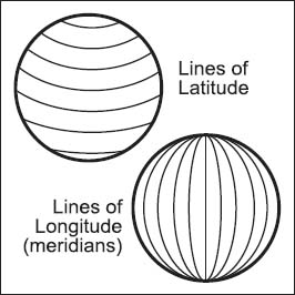
Solar-powered satellites (with backup batteries in case of a solar eclipse) travel about 7,000 miles per hour and circle the globe twice in just less than 24 hours. As they orbit about 12,000 miles above the Earth, they send signals to the ground that can be received by a GPS. When the GPS locates four or more of the satellites, the data can be used to pinpoint the user’s location through trilateration, or the use of geometric techniques that determine the location in three-dimensional space, which is actually the user’s location in terms of latitude, longitude, and altitude.
Simply put, the receiver compares the time a signal was transmitted by a satellite and compares it to the time it was received, a way of telling the distance to the satellite. From there, it contacts the other satellites, gathering the same information, thus pinpointing the receiver’s location. The reason it works is that any time, anywhere on Earth, there are at least four accessible satellites in orbit, which is why you can determine your location even on such remote places as Mt. McKinley or even Mt. Everest. (In fact, in 1999, the U.S. Expedition Team used a GPS to measure the elevation of Mt. Everest at 29,035 feet [8,850 meters], although this result is still debated.)