Modern MeterologyRadar |
What is a hook echo? |
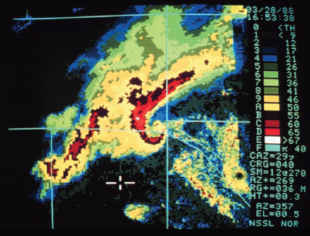
A hook echo—also called a “hook pattern”—is a warning sign that a tornado has possibly formed. On radar, the echo looks kind of like the number “6” and is associated with a mesocyclone within a storm, so it is called a tornadic mesocyclone. The distinctive hook shape was first seen on April 9, 1953, by electrical engineer Donald Staggs, who was monitoring the radar system at the Illinois State Water Survey in Champaign. A hook echo does not necessarily indicate a tornado has definitely formed, but it is a strong indication that it has. On the other hand, tornadoes can and do form without the tell-tale hook echo ever being seen.

A 1988 radar image of clouds near Norman, Oklahoma, shows the distinctive hook echo that is often a precursor to tornadic activity. (NOAA Photo Library, NOAA Central Library; OAR/ERL/National Severe Storms Laboratory)
