Modern MeterologySatellites |
What measurements do weather satellites provide us? |
Early weather satellites transmitted images of clouds and could also take infrared (IR) readings, which allowed for weather monitoring both day and night. With IR sensors, satellites can detect temperature readings, which can also indicate cloud elevation. Modern satellites are capable of many other observations, as well. Detailed images of not only clouds, but also land and sea surfaces and temperatures, provide scientists with information about fog, snow, rain, ocean currents, haze, air pollution, ozone levels, soil moisture levels, airborne dust, and even volcano and forest fire activity. Satellites are also used to take surveys of agricultural activities and vegetation growth.
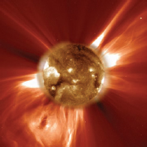
The SOHO spacecraft captured this image of the Sun shooting coronal mass ejections (CMEs) of plasma out into space. CMEs occur every week, and sometimes more than once a day. (NASA/JPL)